
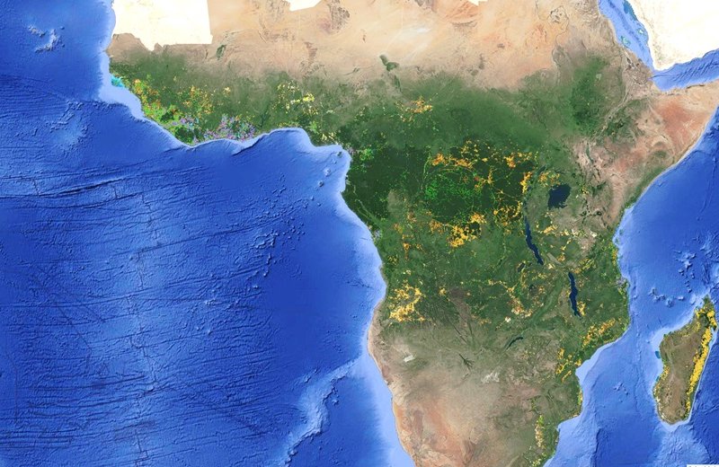
Part of a world map focusing on Africa. Lots of coloured dots indicate the location and type of different land use forms after deforestation.
Photo: © Screenshot of the app
 Read this article in French
- Share this article
- Subscribe to our newsletter
Mapping the diversity of land uses following deforestation across Africa
Africa's forested areas – an estimated 14 per cent of the global forest area – are continuing to decline at an increasing rate – mostly because of human activities to convert forest land for economic purposes. As natural forests are important CO2 and biodiversity reservoirs, this development has a significant impact on climate change and affects the integrity of nature.
To intervene in a targeted manner in the interests of climate protection and biodiversity, there has been a lack of sufficiently good data and detailed knowledge of the various forms of subsequent utilisation of deforested areas to track where forest-related conversions are happening and why. This has now been provided by a new study published in the journal Nature Scientific Reports and led by Robert N. Masolele and Johannes Reiche from Wageningen University in the Netherlands, Martin Herold from the GFZ German Research Centre for Geosciences in Potsdam, and their team.
They used high-resolution satellite data, which they analysed on the basis of local reference data for 15 different types of land use – from crops such as coffee, cashew and rubber to pastureland and mining – with the help of deep learning methods. This enabled them to create the first high-resolution (accurate down to five metres) and continental mapping of land use after deforestation across a wide area of the African continent, including wet and dry forests.
This provides an improved basis for enhancing transparency on where commodity expansion leads to deforestation and for underpinning the strategic planning and implementation of deforestation mitigation measures by governments and forest protection agencies – both in Africa and in the European Union, where a new EU-regulation aims to establish “deforestation-free supply chains” for products made from certain raw materials.
The most important results on land use in Africa
The study reveals a complex web of land uses that emerge after deforestation events. It shows that the causes of forest loss vary from region to region. In general, small-scale cropland is the main driver of forest loss in Africa, with hotspots in Madagascar and the Democratic Republic of Congo.
In addition, commodity crops such as cocoa, oil palm and rubber are dominant drivers of forest loss in the humid forests of western and central Africa, forming an “arc of commodity expansion” in that region. At the same time, the hotspots for cashew are found to increasingly dominate in the dry forests of both western and south-eastern Africa, while larger hotspots for large-scale croplands were found in Nigeria and Zambia. The increased expansion of cacao, cashew, oil palm, rubber, and large-scale croplands observed in humid and dry forests of western and south-eastern Africa suggests that they are vulnerable to future land-use changes by commodity crops.
Classification and outlook
Although the mapping is very extensive, the study recognises that it is difficult to classify certain forms of land use with a high degree of accuracy. Factors such as cloud cover and seasonal variations present limitations that emphasise the need for continuous refinement and validation.
“The study makes a crucial contribution to our understanding of the complex interplay between human economic activities and the environment. Its particular importance lies in the fact that it provides policy-makers, conservationists and scientists with a detailed understanding of the different developments that land undergoes in large parts of Africa after deforestation. This knowledge is crucial for developing targeted conservation strategies, achieving the Sustainable Development Goals and mitigating the environmental impacts of deforestation across the African continent,” emphasises Martin Herold.
(gfz-potsdam/wi)
Reference:
Explore for yourself:
The GEE app with data – Direct Drivers of Deforestation in Africa Explorer


Add a comment
Be the First to Comment