

The automatic weather station provides synoptic weather variables such as rainfall, solar radiation, sunshine hours, wind speed and wind direction, air temperature, air pressure, relative humidity and soil temperature at different depths.
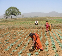
Photo: Seyni Salack/WASCAL
 Download this article in magazine layout
- Share this article
- Subscribe to our newsletter
Monitoring climate change in “data-scarce regions”
Climate change has become one of the most severe challenges to Africa in the 21st century. This is particularly true for West Africa and its Sahel sub-region. Access to data is crucial to enabling the region to develop effective adaptation and mitigation measures and to continue on its way towards sustainable development. For example, to avoid uncontrolled migration causing social and political destabilisation, predictions on population dynamics and applicable estimations of agricultural production are necessary in order to implement programmes providing food security and sustainable livelihoods.
This applies in particular when already existing environmental degradation is accelerated by climate change. But although governmental agencies and scientific institutions regularly collect data on the economic, social or environmental situation, scarce human and technical resources compromise gathering, processing, managing and delivering of the data. In addition, sharing of primary research data – meaning raw data produced by scientists during field work – is practically non-existent. Consequently, researchers unnecessarily invest time and efforts in creating data which may be already there. Thus, in comparison to countries from the Global North, West Africa is assumed to be a “data-scarce region” in terms of access to data created by governmental as well as scientific institutions. This is also reflected by the fact that e.g. from the 831 authors invited for the 5th Intergovernmental Panel on Climate Change (IPCC) report, only 66 (8 %) were African scientists.
WASCAL in a nutshell
The West African Science Service Centre on Climate Change and Adapted Land Use (WASCAL) was initiated in 2010 in close cooperation with West African and German research institutions. It was funded by the German Federal Ministry of Education and Research (BMBF). The Science Service Centre has become an international organisation under the umbrella of the Economic Community of West African States (ECOWAS) with currently eleven member states (Benin, Burkina Faso, Cap Verde, Côte d’Ivoire, The Gambia, Ghana, Mali, Niger, Nigeria, Senegal and Togo). The hub of this regional research network is the Competence Centre located in Ouagadougou, Burkina Faso.
The WASCAL Data Infrastructure – WADI – was developed by Germany’s Research Centre Jülich and the Center for Development Research (ZEF), attached to the University of Bonn, Germany. WADI consists of a central metadata catalogue connected to a repository for research data files, tools for data import, services for storing and publishing geospatial data and a system to import, manage and publish time series data. The data are merged into the central WASCAL portal application, the Data Discovery Portal (DDP), which offers search, visualisation and download tools.
Against this backdrop, the West African Science Service Centre on Climate Change and Adapted Land Use (WASCAL) was initiated in 2010 (see Box above). It aims at strengthening the research infrastructure and capacity in West Africa related to climate change. WASCAL is to enhance the resilience of human and environmental systems to climate change and increased climate variability by providing research-based advice to policy-makers and other decision-makers. To facilitate this, the organisation works in three areas: research & education, data collection & technical infrastructure, and data management & sharing.
Strengthening West Africa’s hydro-meteorological observation network
To improve the availability of high quality hydro-meteorological measurements and to increase our understanding of land-atmosphere processes and their interactions in the context of climate variability and change, advanced and modern near-surface observation systems are needed. The National Meteorological and Hydrological Services (NMHSs) in West Africa maintain networks of measuring stations to collect standard datasets. However, the observation networks are technically outdated or defective, and various additional factors hamper data gathering and dissemination. As a consequence, many essential climate variables had not been observed or reported over the past few decades. As part of its key mandate, WASCAL has initiated the establishment of transboundary observatories to co-produce high quality hydro-climatological datasets and information useful for research, climate monitoring and service delivery.
The setup of meteorological stations followed the specifications of the World Meteorological Organization. In this context, all parameters required to determine potential evapotranspiration (wind speed, global radiation/sunshine duration, air temperature, relative humidity, air pressure and soil temperatures), wind direction and precipitation are measured with a temporal resolution of 10-15 minutes. Hydrological data comprise water and/or discharge levels and chemical water parameters measured with different temporal resolutions. Scientists can create appropriate temporal aggregates and use the data as input for climate and/or water balance models to prepare decision-making in e.g. early warning of climate disasters. All data is entered into the WASCAL Data Infrastructure – WADI (see Box). WADI also includes a component to deliver interactive maps as so-called Web Map Services – a standard used in Spatial Data Infrastructures worldwide. The maps are accessible not only by Geoportals but also by any client using Geographic Information Systems (GIS). More than 500 datasets, time series and interactive maps are integrated into the WADI. An example can be seen in the Box below.
Flood Hazard Index maps in the catchments in Burkina Faso, Ghana and Benin
Integrated in the Flood Hazard Index, flood hazard maps show information on extent, severity and probability of floods. The basis for deriving the flood hazard index maps is formed by the following two datasets: standardised peak runoff rates in cubic metres per second (m³/s) and standardised digital elevation models. These maps were categorised into five classes using the Natural Break (Jenks) method to produce the Flood Hazard Index (FHI). The FHI ranges from 1 – very low flood hazard intensity to 5 – very high flood hazard intensity. The results were verified by local disaster managers by applying principles of the Participatory Geographic Information System. The interactive maps as well as the geospatial files are freely accessible for further processing through WADI.
The research programmes
When starting in 2010, the Competence Centre in Burkina Faso was complemented by two research programmes – the ongoing Graduate Studies Programme and the WASCAL Core Research Programme (2012-2016).
The Graduate Studies Programme consists of ten doctoral programmes and two master’s programmes and is coordinated by WASCAL’s Capacity Building Department. Each of the programmes focuses on a thematic research framework, such as “climate change and energy” or “climate change and education”. The lead universities were selected in a consultative process among the WASCAL countries by considering their scientific and educational strength of faculties in the West African region. Research is mainly conducted within the country where the lead university is located.
For the Core Research Programme the principal research topics – climate and weather, markets and livelihoods, landscape dynamics, risk management and agricultural systems – were identified as substantial to cope with the effects of climate change in the region. Three watersheds – Dano, Vea and Dassari, near the borders of Burkina Faso, Ghana and Benin, respectively – were chosen in order to carry out interdisciplinary research on climate change impacts and mitigation strategies through mapping the peak runoff and flood hazard. They represent areas along a gradient of land-use intensity stretching from rangeland to high-input agriculture.
Wherever appropriate, local stakeholders and their perceptions and knowledge were incorporated in the research. One example is the organisation of the “Farmer innovation contest in rural Ghana”. In contrast to developing solutions by external experts and trying to introduce them to rural practice, small-scale farmers from the Upper East region in Ghana were motivated to publish and share their own solutions to agricultural problems. A broad range of innovation themes were covered, such as novelties in animal husbandry, crop management or storage. Finally three innovators were awarded with prizes during the National Farmers Day celebration. The innovations are published in the WADI for free access. Besides information about the applicants, e.g. basic demographics, provided data comprise information on the theme of the innovation, the problem addressed or obstacles and costs of applying the innovation.
Management and sharing of research data
Most national research institutions in West Africa have neither facilities nor policies to manage and share research data. One reason is the absence of a data sharing culture, a phenomenon which is not limited to West Africa. On the one hand, scientists would be happy to have access to high quality data. On the other hand, there is a lack of willingness to invest time and efforts to share one’s own data with others. Alike, it cannot be ruled out that more informal channels of data exchange among researchers, e.g. cloud solutions such as Dropbox, are considered sufficient, instead of sharing data following open data principles such as F.A.I.R. (Findable, Accessible, Interoperable and Re-usable, which are guiding principles developed by the international initiative FORCE11 in 2016).
However, international developments for safeguarding good scientific practice are increasingly demanding the sharing of research data. Thus, more and more data-intensive international research projects as well as national and international funders require establishing open access to data.
Handling intellectual property and copyrights
Legal uncertainty, for example due to missing licensing schemes considering intellectual property and ownership rights, reduces the motivation to share and re-use data. Therefore, in an initial step, in a participatory process, WASCAL has established a transboundary data sharing policy among the involved NMHSs and the WASCAL research community. This achievement cannot be overemphasised given the complexity of national peculiarities in the handling of intellectual property and copyrights as well as the aforementioned funding constraints. The ‘open data’-oriented policy outlines authorship rights and commitments. One main commitment is to upload data into the WADI catalogue within a certain period after data has been created. Otherwise researchers can claim the right of first publication so that access to the data remains restricted until a paper or a thesis is published. Privacy protection is another important issue in the data policy. It states that personal information e.g. within household surveys needs to be anonymised before publishing, unless prior written permission was given by the interviewed person to publish personal information.
Around 90 per cent of the data in the WADI catalogue originates from research carried out in the Core Research Programme. Only little comes from the Graduate Studies Programme or from researchers in the Competence Centre. In order to create an acceptance of the benefits of data sharing and the importance of investing time and efforts to share data, a training with scientists of the Competence Centre and doctoral students of the Graduate Studies Programme was organised to increase knowledge on how to prepare, describe and share data online using the WADI. But this training with a high number of participants was a single event. Continuous assistance could not be provided to the students because of insufficient data management staffing at local level.
In contrast, good experience was gained in training of small groups or individual supervision sessions for Core Research Programme scientists. These trainings, organised by the data management unit at Germany’s Center for Development Research of the University of Bonn (ZEF), were followed by continuous supervision and support in the process of standardising, documenting, licensing and uploading data to the WADI.
Lessons learnt
To establish continuous data flows from research activities carried out, students at the partner universities have to be motivated and assisted by trainings in small groups, or even individually. Prior to the upload and accessibility of the data, the responsible data manager needs to look into each of the data files to be uploaded into the WADI in order to advise the students on how to comprehensively describe the data by using the online interfaces. Further privacy protection of survey data has to be checked as well as which exchange formats to use, how to name the files, how to add useful data quality assessments to the metadata and how to license the data in compliance with the data sharing policy. At the end of this process, the data manager must make sure the metadata is consistent and complete before publishing it.
Given that there are eleven partner universities, each with around ten students per batch, this cannot be undertaken by a relatively small data management unit like the one at the WASCAL Competence Centre alone. Thus, delegating tasks to the local level could be a solution. Based on a train-the-trainer concept, members of the IT departments at the partner universities could be skilled by the WASCAL data management unit to take over responsibilities and maintenance of the database. These local contact points would in turn train and supervise the students at their university. It is crucial for this approach to be coordinated with and supported by the executive boards at the partner universities. This could have the positive side effect that the universities would gain first experiences with research data management to make them better prepared for the increasing demand of research data sharing in the future. In a further step, the theory of research data management could become part of the scientific curriculum of the studies programmes. It is also recommendable to develop training material for the students. An e-learning platform providing, for example, videos showing how to use the WADI for publishing data could be helpful.
A permanent funding of local and skilled staff providing continuous as well as individual support to research activities together with reliable access to infrastructure including user-friendly data services can be seen as the basic prerequisite for successful data management within the institutional network in WASCAL. At regional level, the WASCAL data management team are also conducting the WeDataMIND initiative (West African Distributed Data and Metadata Infrastructure and Networks for data Discovery and Dissemination) to facilitate discovery of and access to information on existing data sources, data providers and data policies, and to promote their dissemination. The concept resides on automatic sharing of metadata or data available in each organisation. By interconnecting (federating) the organisation’s data and metadata infrastructure and servers through suitable web services and search engines, an organisation will be able to share its data/metadata under common data sharing policies, and then discover and have access to those existing in other organisations.
Antonio Rogmann works as senior data manager at the Center for Development Research, University of Bonn, Germany.
Ralf Kunkel is a senior scientist and data manager at the Research Centre Jülich, Germany.
Seyni Salack works as senior researcher and coordinator of WASCAL Observation Networks at the WASCAL Competence Centre, Ouagadougou, Burkina Faso.
Belko A. Diallo works as senior data manager at the WASCAL Competence Centre, Ouagadougou, Burkina Faso.
Contact: arogmann@uni-bonn.de
References and further reading:
Website of CODATA: Open Data for Science and Sustainability in Developing Countries
The FAIR Guiding Principles for scientific data management and stewardship
Website to FORCE11
Website to WASCAL data discovery portal
Website to WASCAL’s Core Research Programme
Website to WASCAL’s Graduate Studies Programme
Add a comment
Be the First to Comment